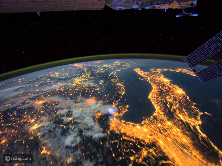
An amazing video of the picturesque planet Earth filmed through satellite

An Earth Observation Satellite is an artificial satellite specially made to observe and monitor the Earth from an orbit around the Earth at an altitude of about 600 km . It is used in weather exploration, meteorology, rain monitoring, environmental monitoring, as well as geographical and geological surveys of the Earth's surface. From a technical point of view, some of these satellites are used for espionage, but the expression “Earth observation satellites” means in the first place that they are for peaceful civilian purposes. For the Earth Observation Satellite, a distinction is made between the satellite itself and the type of scientific equipment it carries.
These satellites are lifted to relatively close heights between 500 and 600 kilometers from the Earth's surface. This necessitates adjusting its height from time to time, because its friction with the air makes it fall slowly towards the ground. The European Space Agency ( ESA ) has sent the ERS-1, ERS-2 and Envisat satellites, as well as the MetOp remote Earth observation satellite, all of them hovering in their orbits at an altitude of about 800 km. It also sent three other satellites: Proba-1, Proba-2, and SMOS to measure the salinity of sea water [SMOS]. It monitors the Earth from a height of 700 km.
History
The first aerial photographs were taken in 1858. In 1904, the German engineer Alfred Maul succeeded in taking pictures of the Earth by means of a missile.
The first images taken for military purposes were from a satellite in 1959, and this satellite was called the “Kayhole Moon”, meaning “the keyhole moon”, within the Corona program. On August 10, 1960, the first Earth exploration satellite was successfully completed within the framework of the Corona program. On April 1, 1960, the TIROS-1 satellite was launched for weather monitoring purposes. Then Landsat-1 was launched in 1972 to monitor the Earth and record data with the Digital Multispectral Scanner System. In 1975, the GEOS-3 satellite was launched, the first satellite to use radar for measurements. In 1978, the Nimbus-7 satellite was provided with devices that enable it to distinguish between the colors of the oceans. Nimbus-7 was the first satellite to monitor the environment. And behind this satellite are satellites carrying special devices, including “Sewives” and “Modis ” on the Aqua satellite..

Observations were made during the Skylab and Space Shuttle missions by the Earth Survey radar in programs STS-59 and |STS-99 and the Space Radar Laboratory STS-68. And the Landsat program, which was called a program to survey natural resources on the ground, and this program - the Lancet program - had begun in 1966.
Devices and their purposes
Earth observation satellites operate by passive measuring methods - that is, simply imaging ordinary light - or positive means - meaning that they send light or radar rays on the ground and on the clouds, record and analyze the reflected ones, and calculate the amount of their temperature. They belong to passive sensors in general optical sensors, and they record light and light ranges in the infrared and ultraviolet range . It uses what is called an atmospheric window , which is ranges of wavelengths of light in which the air’s permeability is high (because the atmosphere absorbs some “colors of light” and allows others to pass through).
There are positive measurement methods for the Earth, which are done by means of radar , sometimes called ( LIDAR ). It provides data on the shape of the Earth's surface. The accuracy of its recordings is several centimeters on the ground, and thus it is possible to measure the smallest displacement that occurs in the surface of the Earth. The importance of this method stems from the fact that it does not depend on the presence of clouds or not, because the radar rays penetrate through the clouds. By means of this positive method of radar measurement, it is possible to form stereoscopic models of the Earth's surface.
Lidar: The LITE space lidar technology experiment, which was on the space shuttle in 1994, and through which it was possible to measure dust and clouds from space, and the first lidar satellite was established, which is the CALIPSO satellite .
Spectrometer : It measures several spectra as it contains 15 channels, and it can also small ranges of light (between 15 to 200 colors).
Scattering instrument (light scattering measurement): to measure wind movement, wind strength and direction over sea level,
SAR radar, which is an aperture analytical radar
laser altimeter,
A scale that uses microwave radiation to measure terrestrial elevations and sea and ocean surface height.

Mapping
Maps can be drawn with the help of satellites that hover at relatively low altitudes above the Earth's surface (elevations between 500 and 800 km). Among those maps were the RADARSAT-1 and TerraSAR-X satellites, which use multiple radar beams to measure the Earth.
Source: websites

